
Geo Recovery - Photo geotagging without account

Geotag photos with AI. Download them with GPS inside.

Need to add GPS data to photos in bulk? Geo Recovery uses AI photo geotagging to find where your shots were taken, lets you review each marker on the map, and downloads your originals with GPS coordinates embedded in EXIF metadata. This is built for DSLR and archive photos with missing GPS metadata.

Your originals never leave your browser. Only lightweight thumbnails are sent for analysis. No Photoreka account required — one payment for the whole batch, €0.012 per photo, VAT included.

Originals stay in your browser One payment per batch GPS injected into EXIF

How it works

How to geotag photos with AI (4 steps)

No onboarding, no catalog setup, no credits to buy. Upload, pay, review, download.

  1. 01

    Upload your photos

    Drag and drop your photos — JPEGs, RAW files, HEIC, anything. Your originals are saved locally in the browser only. Lightweight thumbnails are generated and sent for AI analysis. No account needed.

  2. 02

    One-time payment

    Pay once for the entire batch: €0.012 per photo, VAT included, with a €2.40 minimum. No subscription, no credits to top up.

  3. 03

    AI geolocates at scale

    The same engine that powers the Photoreka platform handles bulk photo geotagging, analyzing every photo in parallel by reading architecture, landscapes, signage, and lighting conditions. Only confident matches are placed on the map — uncertain photos are flagged as unknown, never guessed.

  4. 04

    Review, correct & download

    Inspect every placed marker on the interactive map. Click any pin to see the photo and its address, move it if needed, or search for the correct location by name. Click Download — your original files come back with GPS EXIF data injected, pixel-perfect and unchanged otherwise.

Features

Built for bulk geotagging and EXIF GPS writeback

Everything in Geo Recovery is designed so you spend less time configuring and more time with your photos — wherever they were taken.

Originals stay in your browser

Your original files are stored only in your browser's local storage (IndexedDB). Only analysis-grade thumbnails are sent to the AI. Your originals are never transmitted — they never leave your device until you choose to download them.
Bulk-scale AI inference

The same AI engine that powers Photoreka processes thousands of photos in parallel. No need to queue them one by one — upload the whole batch and let the system work through it.

GPS injected into EXIF

The output is your exact original file with GPS coordinates written directly into the EXIF metadata. Open it in Lightroom, Finder, Capture One, or any EXIF-aware tool and the location is there.

Interactive map review

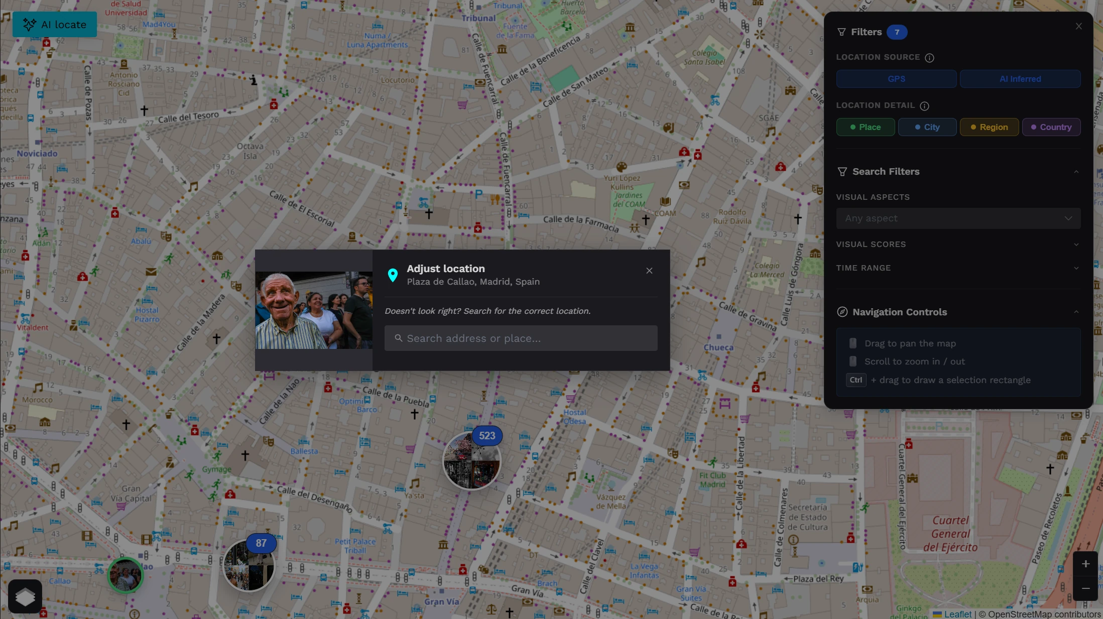
Every located photo appears as a marker on a full-screen interactive map. Click any cluster to explore what was shot there, inspect individual markers, and confirm or correct the AI's placement before downloading.

Manual correction

No AI placement is final. Every marker has an edit button. Click it to search for the correct location by name or drag the pin on the map. Your corrections are what end up embedded in the EXIF — you always have the final word.

One payment, no strings

No ongoing subscription, no credit balance to maintain. Pay once for the batch, review the map, download your enriched files. Done. If you come back later, start a new session and pay once more.

Interactive Map Review

Every photo on the map. Every pin yours to move.

Once the AI has processed your batch, every located photo appears as a clustered marker on a full-screen interactive map. Explore by cluster, zoom in, click any marker to see the photo thumbnail and the inferred address. This is practical photo geotagging with a visual review step before EXIF write back.

Not happy with a placement? Click the edit button, search for the correct location by name or drag the pin on the map. Your correction is what gets written into the EXIF on download — the AI's guess never overrides your judgment.

No account needed · Pay once
Geo Recovery interactive map

Privacy

Your photos never leave your device

Geo Recovery stores your original files in your browser's local storage (IndexedDB). Only thumbnail-sized analysis copies are sent to the AI — just enough for it to read visual context. When you download, your original pixels come back untouched, with GPS coordinates added to the EXIF layer. Nothing is kept on our servers after the session ends.

Use cases

Who needs bulk EXIF GPS recovery

If you have photos without GPS and want them back with coordinates embedded — without setting up an account or learning a new tool — this is it.

  • Film digitizers

    Just scanned hundreds of slides or negatives from your analogue archive? Batch-locate them all at once and let the AI embed the GPS back into the files — from a single paid session.

  • Pre-GPS camera bodies

    Shot years of travel with a DSLR that had no GPS? Upload the whole collection, pay once, and recover the geography hidden in every pixel — from the architecture, the landscapes, the light.

  • Inherited photo collections

    Working with a digitized family or editorial archive with no metadata? Process thousands of unlabeled photos in a single batch and receive the originals back, location-enriched.

  • Journalists & documentarians

    Managing a backlog of editorial or documentary shoots with missing location metadata? One upload, one payment, and you receive back the originals with GPS data embedded — ready for any CMS or archive.

FAQ

Frequently asked questions

Everything you need to know about Geo Recovery

Upload the photos you already took, let Geo Recovery analyze lightweight thumbnails with AI, review each inferred pin on the map, correct anything you want, and then download your original files with GPS coordinates written into EXIF metadata.

Upload your photos to Geo Recovery, pay once for the batch, and let the AI analyze each image to infer the location from visual context (architecture, landmarks, signage). Review the interactive map, correct any pins if needed, then download your originals with GPS coordinates written into the EXIF metadata.

No. Your original files are stored only in your browser (IndexedDB). Only thumbnail-sized versions are sent to the AI for visual analysis — just enough for it to read architectural details, landscapes, and visual context. Your originals are never transmitted to Photoreka's servers.

Photo geotagging means adding GPS coordinates to a photo's EXIF metadata so the location shows up in photo apps and catalogs. Geo Recovery does this in bulk and lets you review every pin before the EXIF GPS is written.

JPEG, HEIC, WebP, and PNG. Soon we will support RAW formats (CR2, CR3, NEF, ARW, ORF, RAF, DNG, and others). GPS is injected into standard EXIF fields, fully compatible with Lightroom, Capture One, Finder, Photos, and any EXIF-aware tool.

Results are typically at city or district level. The AI reads visual context — architecture, landscapes, signage, lighting conditions — and filters out low-confidence guesses. Only reliable matches are placed on the map. Street-level precision is never claimed, but the placed location is the AI's honest best guess.

Photos the AI cannot locate with confidence appear in the results as "unknown" — no marker, no coordinates invented. You can still include them in the download; they come back as-is, without any GPS modification.

Yes, always. Every marker has an edit button. Click it to search for the correct location by name or drag the pin anywhere on the map. Your correction replaces the AI result and is what gets written into the EXIF on download.

You pay once for the full batch at the time you submit it: €0.012 per photo, VAT included, with a €2.40 minimum per batch. There is no subscription and no expiry on your session until you download. If you want to process another batch later, you start a new session and pay once more.

Probably not. The main Photoreka platform includes richer analysis: color palettes, aesthetic scoring, semantic tagging, natural-language search, a 3D atlas, a portfolio builder, and Lightroom integration. Geo Recovery is the lightweight, frictionless option for people who only need GPS recovery without setting up an account.

Upload your photos. Pay once. Get them back with GPS.

Thousands of photos. One batch. AI reads each frame, places it on the map, lets you correct anything, then injects GPS coordinates directly into the EXIF of your originals. No account, no subscription, no fuss.